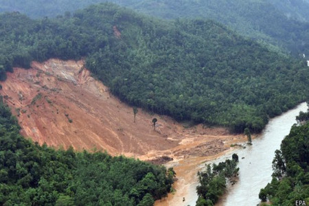
According to the NBRO study, around 13,000 square kilometers of lands spread over in Badulla, Nuwara-Eliya, Kandy, Matale, Ratnapura, Kegalle, Kalutara, Galle, Matara and Habantota- are landslide –prone.
The study has found that incidences and frequency of landslides are growing, and it is common have such disasters including cutting failures along with every bout of rain.
The major causes for the increase in the frequency of landslides are un-planned land use practices and unplanned intensive cultivation, ever increasing non- engineered constructions, construction blocking the waterways, construction in the reservation area of water bodies, deforestation and human intervention.
Another study done Professor in Earth Resources Engineering University of Moratuwa and President of Institute of Geology Sri Lanka Prof. Ranjith Premasiri, major landslides which occurred during the past two decades have claimed thousands of lives, about 175,000 people have been rendered homeless. Besides, damages in multi-millions have been caused to property.
He says in his study the climate of Sri Lanka varies from semi-arid to mild temperature.
Sri Lanka can be divided in to three main climatic zones on the basis of annual rainfall- wet zone (over 3000mm annual rainfall), intermediate zone (2000 to 3000mm), and dry zone (less than 2000mm).
“Landslides are very often triggered by continuous rainfall characterized by showers of high intensity that occur for short periods of time. Central hilly area of Sri Lanka experiences rain from two monsoons, North-East and South-West,” he said.
Sudden opening and progressive widening of cracks on sloped surfaces or on the walls of building are signs of landslides.
(Kelum Bandara)


